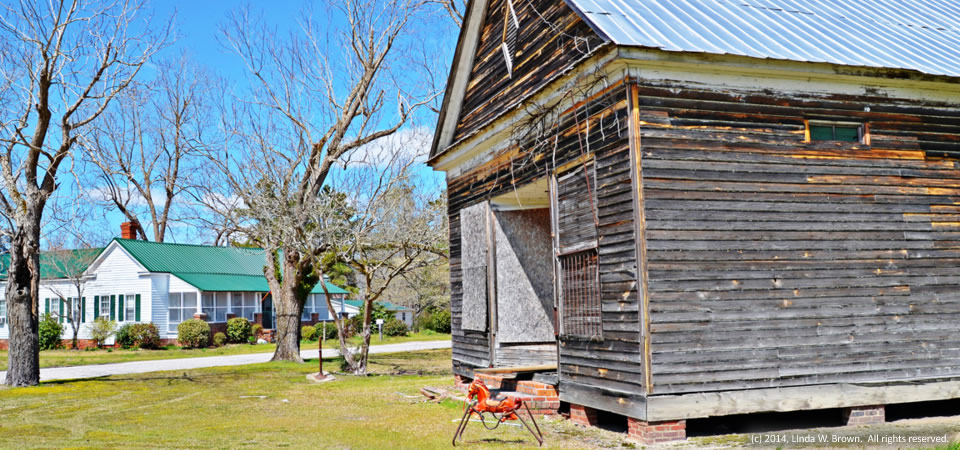
Rocking Horse, Workman Crossroads, S.C.

Rocking horse and old store, Workman Crossroads, S.C.

Kingstree, S.C., photographer Linda W. Brown found an old country store, a vintage rocking horse and a restored farmhouse standing within yards of each other at Workman Crossroads in western Williamsburg County.

Williamsburg County, which is about 75 miles north of Charleston, S.C., has a population of just under 34,000 people.  Population peaked in 1950 at 43,807, but has dropped slowly since then.

About two-thirds of county residents are black, with almost  all of those remaining being white.  Only 2 percent of those in the county are of Hispanic descent.  Some 32.8 percent of residents live in poverty, according to the Census.  Of the county’s 1,921 firms, 36.5 percent are black-owned — a percentage that is three times South Carolina’s average.

Photo taken March 30, 2014, by Linda W. Brown.  All rights reserved.
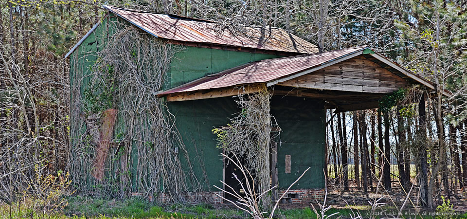
Tobacco barn, Williamsburg County, S.C.

Tobacco barn, Williamsburg County, S.C.

An old tobacco barn, still standing on McIntosh Road in Williamsburg County, has given way to less production and new methods of processing what is grown, retired Kingstree editor and photographer Linda W. Brown observed recently.

Williamsburg County, which is about 75 miles north of Charleston, S.C., has a population of just under 34,000 people.  Population peaked in 1950 at 43,807, but has dropped slowly since then.

About two-thirds of county residents are black, with almost  all of those remaining being white.  Only 2 percent of those in the county are of Hispanic descent.  Some 32.8 percent of residents live in poverty, according to the Census.  Of the county’s 1,921 firms, 36.5 percent are black-owned — a percentage that is three times South Carolina’s average.

Photo taken March 30, 2014, by Linda W. Brown.  All rights reserved.

A little love, Sardinia, S.C.

14.0404.renovation

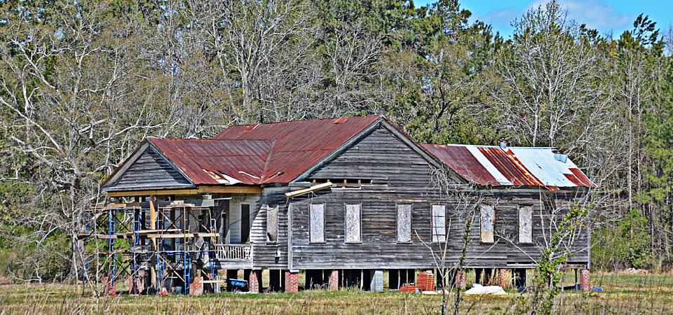
This old farmhouse in the Sardinia community in rural Clarendon County seems to be getting a little long-needed loving. Retired editor and photographer Linda W. Brown of Kingstree, S.C., noted how the scaffolding across the house’s front porch indicates it is getting a new lease on life.

Clarendon County has 34,357 people, according to the U.S. Census Bureau’s 2012 population estimate.  About half of the county’s residence are white; the other half are black.  Some other statistics:

  • High school graduation rate of those 25 or older:  76.3 percent.
  • Bachelor’s degree graduates:  13.8 percent
  • Median household income:  $33,267
  • Poverty rate:  22.8 percent
  • Unemployment rate, November 2013: 9.9 percent (2.5 percent higher than the state average)
  • Black-owned firms:  30.1 percent (18 points higher than state average)
  • Women-owned firms:  35.4 percent (8 points higher than state average)

Copyrighted photo is by Linda W. Brown; taken March 30, 2014.  All rights reserved.

Gopher tortoise, Ridgeland, S.C.

Gopher Tortoise Square, Ridgeland, S.C.

Gopher Tortoise Square, Ridgeland, S.C.

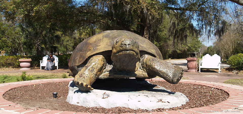
This bronze of a gopher tortoise is the focal point of a community square in Ridgeland near the southern tip of South Carolina.

According to a marker at the park, which is adjacent to the railroad tracks around which the town grew after 1860, Ridgeland originally was known as “Gopher Hill” because of the abundance of tortoises (Gopherus Polyphemus) that inhabited the sand hills of the area.  The reptiles, which live up to 60 years, spend much of their life in deep burrows.  Now an endangered species, they’re not too abundant these days.

Ridgeland has been the seat of Jasper County since it was created in 1912.  Before then the railroad tracks of the Charleston & Savannah Railroad served as the boundary between Beaufort and Hampton counties and Ridgeland was split between them.

Ridgeland grew by 60 percent from 2000 to 2010, when the population was just over 4,000 people, according to Census figures.  Jasper County, population 25,833, is just over the river from Savannah, Ga.  Its location near the metro area likely is why poverty in Jasper County (21.4 percent) is half that of Allendale County to the north.  Ridgeland has a poverty rate of more than 24 percent.

Photo by Andy Brack, taken on March 2, 2014.  All rights reserved.

Happy Taxi, Ridgeland, S.C.

Happy Taxi Cab Co., just outside of Ridgeland, S.C.

Happy Taxi Cab Co., just outside of Ridgeland, S.C.

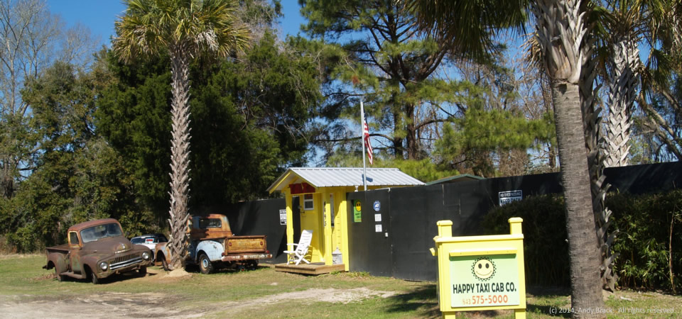
Despite the high fence and signs warning people to “keep back” and “no trespassing” and “video surveillance,” we got a kick out of the Happy Taxi Cab Co. just outside Ridgeland, S.C., on S.C. Highway 336.  You can see old trucks from days gone by and get a feel of thrift mixed with entrepreneurship.

Ridgeland, the county seat of Jasper County, grew by 60 percent from 2000 to 2010, when the population was just over 4,000 people, according to Census figures.  Jasper County, population 25,833, is just over the river from Savannah, Ga.  Its location near the metro area likely is why poverty in Jasper County (21.4 percent) is half that of Allendale County to the north.  Ridgeland has a poverty rate of more than 24 percent.

Photo by Andy Brack, taken on March 2, 2014.  All rights reserved.

Old filling station, Coosawatchie, S.C.

14.0307.filling
Old gas station, Coosawatchie, S.C.


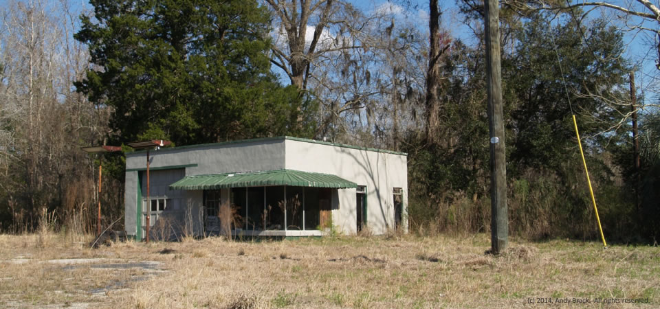
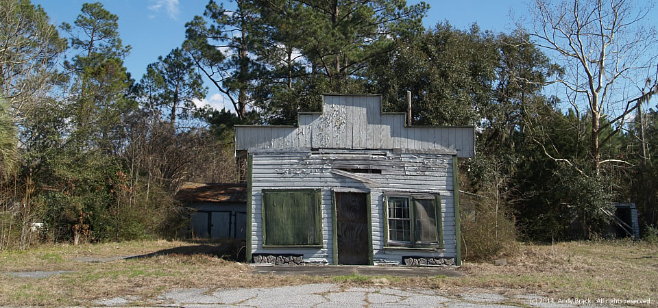
This old filling station, located near this dilapidated store in Coosawatchie, S.C., recalls days gone by in which cars headed between the North and Florida tumbled through the Palmetto State.  The one-bay garage along what is now S.C. Highway 462 may have been part of U.S. Highway 17 in years before Interstate 95.

Coosawatchie is in Jasper County, population 25,833, which is just over the river from Savannah, Ga.  Its location near the metro area likely is why poverty in Jasper County (21.4 percent) is half that of Allendale County to the north.  However, parts of the county around Ridgeland and Coosawatchie, which are further away from the Savannah area, feature a lot of the same strife as in Allendale County.

Photo by Andy Brack, taken on Feb. 28, 2014.  All rights reserved.

Peeling paint, Coosawatchie, S.C.

Dilapidated storefront, Coosawatchie, S.C.

Paint peeling from this shuttered storefront along S.C. Highway 462 in Coosawatchie, S.C., reflects deep poverty that is found in rural areas along Interstate 95 in the Palmetto State.  This photograph was taken just a few hundred  yards away from the beautiful, meandering Coosawatchie River.

Jasper County, population 25,833, is just over the river from Savannah, Ga.  Its location near the metro area likely is why poverty in Jasper County (21.4 percent) is half that of Allendale County to the north.  However, parts of the county around Ridgeland and Coosawatchie, which are further away from the Savannah area, feature a lot of the same strife as in Allendale County.

Photo by Andy Brack, taken on Feb. 28, 2014.  All rights reserved.

Coosawatchie River, S.C.

The Coosawatchee River meanders under an I-95 bridge.
The Coosawatchie River meanders under an I-95 bridge.

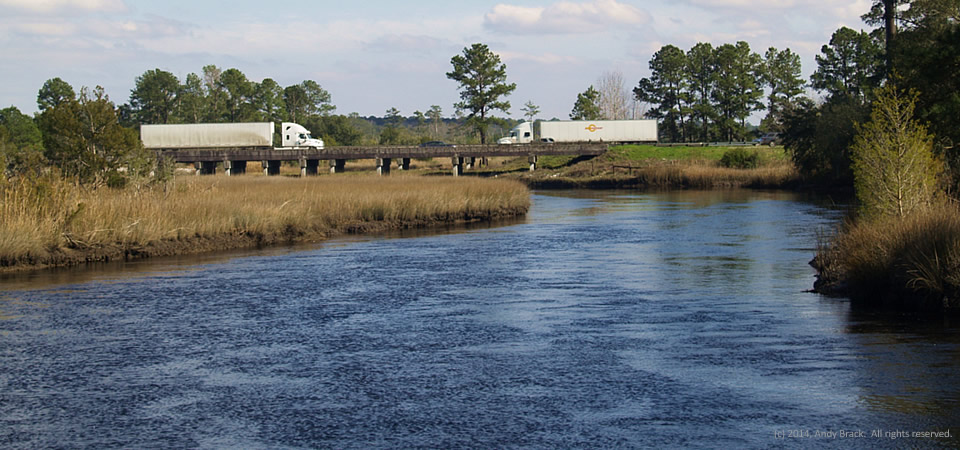
The Coosawatchie River in Jasper County flows under a bridge that’s part of Interstate 95.  The interstate defines much of South Carolina’s Corridor of Shame, an area of high poverty and low educational attainment that stretches along the highway.

Jasper County, population 25,833, is just over the river from Savannah, Ga.  Its location near the metro area likely is why poverty in Jasper County (21.4 percent) is half that of Allendale County to the north.  However, parts of the county around Ridgeland and the nearby river, which are further away from the Savannah area, feature a lot of the same strife as in Allendale County.

Photo by Andy Brack, taken on Feb. 28, 2014.  All rights reserved.

Livery, Mayesville, S.C.

Old livery, Mayesville, S.C.

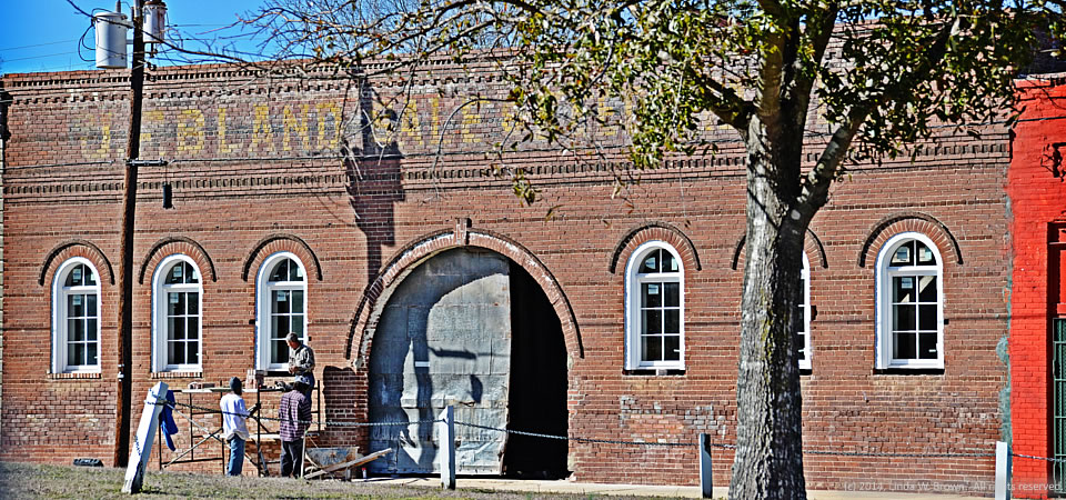
The old Livery Stable in Mayesville, S.C., appears to be undergoing renovation, retired editor and photographer Linda W. Brown writes. The livery is across the railroad right-of-way from the Kineen Hotel, pictured earlier in the month.

Sumter County’s Mayesville, population 731, grew up along the Wilmington and Manchester Railroad, she writes.

“It reached its heyday at the turn of the 20th Century with two banks, a hotel and various other businesses associated with a farming and railroad community. What remains of the Kineen Hotel still stands, but is in very bad repair. The old railroad bed has been removed  and the old railroad right-of-way now serves as green space thought the center of town.”

Sumter County, which is home to Shaw Air Force Base, is comprised of 108,052 people.  Just under 50 percent are white; 47 percent are black. The poverty rate is estimated to be 18.2 percent in the county, but it is a much higher percentage in places like Mayesville.  Poverty there has been estimated to be 36.5 percent for all, but 49.5 percent for children under 18.

Photo taken in February 2014 by Linda W. Brown.  All rights reserved.
Kineen Hotel, Mayesville, S.C.

Kineen Hotel, Mayesville, S.C.

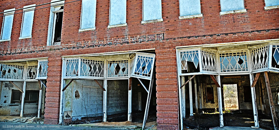
This two-story brick hotel in Mayesville, S.C., is a shadow of its former self.  Intricate glasswork hangs awry alongside broken windows.  Second-floor windows are boarded-up.  The first floor is virtually gutted.

Kingstree, S.C., photographer Linda W. Brown captured this shot earlier this month on a trip through the Sumter County town.  Mayesville, population 731, grew up along the Wilmington and Manchester Railroad, she writes.

“It reached its heyday at the turn of the 20th Century with two banks, a hotel and various other businesses associated with a farming and railroad community. What remains of the Kineen Hotel still stands, but is in very bad repair. The old railroad bed has been removed  and the old railroad right-of-way now serves as green space thought the center of town.”

Sumter County, which is home to Shaw Air Force Base, is comprised of 108,052 people.  Just under 50 percent are white; 47 percent are black. The poverty rate is estimated to be 18.2 percent in the county, but it is a much higher percentage in places like Mayesville.  Poverty there has been estimated to be 36.5 percent for all, but 49.5 percent for children under 18.

Photo taken in February 2014 by Linda W. Brown.  All rights reserved.