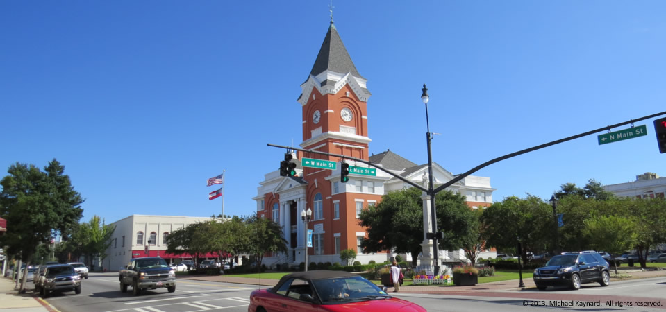
Courthouse, Statesboro, Ga.

13.1116.statesboroct

If you drive through the college town of Statesboro in mideastern Georgia, you probably wouldn’t think that 50.7 percent of residents lived in poverty, according to a five-year average by the U.S. Census.  Sure, there are parts of town that have challenges, but it certainly doesn’t look like half of the residents are poor.

About the best we can figure is that the Census must have counted a lot of the 20,000+ students from Georgia Southern University as residents who live below the poverty level.  And in a small town like Statesboro — population 29,779 — the number of college students, indeed, may make the community look statistically poorer than it is.  (Anybody know differently or have a better explanation?)

The community is 54 percent white and 40 percent black.  Its median household income is $19,554, according to the Census.  If the Bureau is counting college students, the skewed demographics that Statesboro is experiencing can have a dramatic impact because it won’t be able to attract medium- and higher-end stores and shops. In a story told us by a newspaperman during a September visit, we learned that a major grocer won’t move to town because of Statesboro’s relatively low median household income.  And that’s a shame because the community seems like it’s got a lot going for it — something the fast-food chains certainly have discovered.

Statesboro is the county seat of Bulloch County, which has 72,694 people (2012), two thirds of which are white.  Just over 30 percent of residents live in poverty.  The median household income for the county is $33,902.

Photo taken Sept. 23, 2013 by Michael Kaynard.  All rights reserved.
Historic marker for tourism, Burke County, Ga.

Historic marker, Ivanhoe farm, Burke County, Ga.

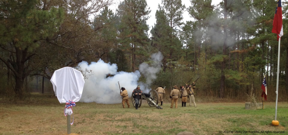
Rural areas in Georgia may start experiencing an uptick in tourism thanks to a state-sponsored program to highlight what was once topic-non-grata — Union Gen. William T. Sherman’s slashing March to the Sea.

The Georgia Department of Transportation is providing almost $700,000 to the nonprofit Georgia Civil War Heritage Trails Inc., to erect interpretive historic markers along routes used by Union and Confederate armies almost 150 years ago around Atlanta and along the Sea campaign.

In the photo above, re-enactors appeared at the unveiling of a new marker at Ivanhoe, the Dye family farm in Burke County.  According to Molly Dye Franklin, who provided the picture, the farm was home to a Nov. 26, 1864, skirmish between Union and Confederate troops — one of more than 100 skirmishes across the Peach State. She said the effort could help rural counties like Burke County, which needs tourism and help to rise above endemic poverty.

Burke County, which had about 23,125 people in 2012, is evenly split in the numbers of white and black residents (49 percent each).  Its population peak was in 1920 when it had almost 31,000 people; its low point was in 1970 when it had 18,255 people.

The county, located between Augusta and Statesboro, has a median household income of $32,188.  Some 28.6 percent of people live in poverty, according to a five-year Census estimate.

Photo taken in November 2014 by Molly Dye Franklin.  All rights reserved.

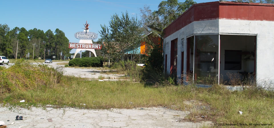
Paradise Restaurant, Cooperville, Georgia

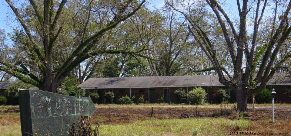
Empty Paradise Hotel, Cooperville, Ga.

The old Paradise Restaurant, which apparently suffered a fire in recent years, is closed, as is the gas station at right.  Both are adjacent to a spooky old motel featured on Halloween in this post.

The complex is in Cooperville at the intersection of U.S. Highway 301 and Georgia Highway 17 in Screven County, Ga., which got started after the Revolutionary War and soon became part of the Black Belt of Georgia where cotton became an important staple crop tended by enslaved African Americans.

The county’s population jumped from 3,019 in 1800 to 8,274 by 1860, according to Census figures.  While it had 14,593 people in 2010, the county lost an estimated 391 people — 2.7 percent — by 2012, according to the U.S. Census.  In 2010, Some 25.4 percent of county residents lived below the federal poverty level, 9 points higher than the state average.

Photo taken Sept. 23, 2013, by Andy Brack.  All rights reserved.

Spooky, Cooperville, Georgia

13.1031.spooky
Spooky, abandoned motel, Cooperville, Ga.

Doesn’t this abandoned motel look plain spooky — a place NOT to be on Halloween?

It’s in rural Screven County, Ga., about 12 miles south of the county seat, Sylvania, at the intersection of U.S. Highway 301 and Georgia Highway 17.  Next to the hotel is the abandoned Paradise Restaurant, that kind of reminds us of the Lobster House, also in Highway 301, about 45 minutes northeast.

Screven County got started after the Revolutionary War and soon became part of the Black Belt of Georgia where cotton became an important staple crop tended by enslaved African Americans.

The county’s population jumped from 3,019 in 1800 to 8,274 by 1860, according to Census figures.  While it had 14,593 people in 2010, the county lost an estimated 391 people — 2.7 percent — by 2012, according to the U.S. Census.  In 2010, Some 25.4 percent of county residents lived below the federal poverty level, 9 points higher than the state average.

Photo taken Sept. 23, 2013, by Michael Kaynard.  All rights reserved.

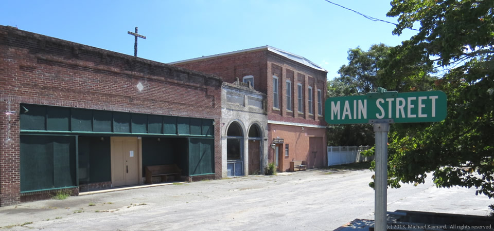
Main Street, Rocky Ford, Ga.

Rocky Ford, Ga.
Rocky Ford, Ga.

Rocky Ford, Ga., a circa 1870s town with “untold treasures and endless opportunities” according to this site, is home to about 200 people in rural Screven County in eastern Georgia.

According to photographer Brian Brown, “After putting much of her personal wealth and energy into the restoration of her beloved hometown of Rocky Ford, Greta Newton is now offering its historic commercial core for sale. Without her passion for the history of this place, it would have suffered the same fate as so many of our forgotten small towns in Georgia.”

Rocky Ford is in Screven County, which had 2,675 people in 2000, according to the Census.  Screven County got its start after the Revolutionary War and soon became part of the Black Belt of Georgia where cotton became an important staple crop tended by enslaved African Americans.

The county’s population jumped from 3,019 in 1800 to 8,274 by 1860, according to Census figures.  While it had 14,593 people in 2010, the county lost an estimated 391 people — 2.7 percent — by 2012, according to the U.S. Census.  In 2010, Some 25.4 percent of county residents lived below the federal poverty level, 9 points higher than the state average.

Photo taken Sept. 23, 2013, by Michael Kaynard.  All rights reserved.
Farmhouse in town, Sylvania, Ga.

Farmhouse in Sylvania, Ga.

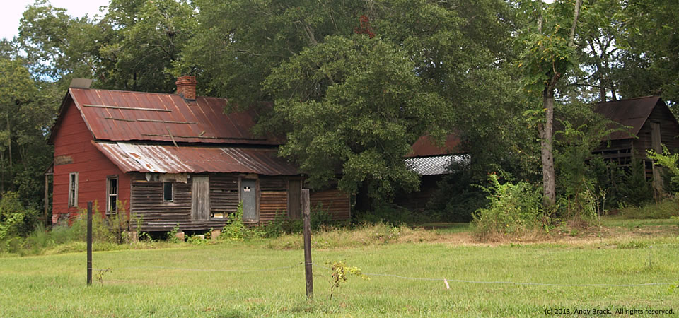
In many towns across the rural South, it’s not hard to find old homes near downtown that were once at the edge of town.  They blended a little of country and city at the same time.

While decrepit now, this old house might soon be in for an upfit, based on some of the stuff in the yard that’s outside of the picture.  The property sits about two blocks off the main street in Sylvania, Ga.

Sylvania, the county seat of Screven County, had 2,675 people in 2000, according to the Census.  Screven County got its start after the Revolutionary War and soon became part of the Black Belt of Georgia where cotton became an important staple crop tended by enslaved African Americans.

The county’s population jumped from 3,019 in 1800 to 8,274 by 1860, according to Census figures.  While it had 14,593 people in 2010, the county lost an estimated 391 people — 2.7 percent — by 2012, according to the U.S. Census.  In 2010, Some 25.4 percent of county residents lived below the federal poverty level, 9 points higher than the state average.

Photo taken Sept. 22, 2013, by Andy Brack.  All rights reserved.

Storage, Sylvania, Ga.

Agricultural storage, Sylvania, Ga.

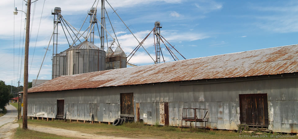
Here’s something found in many rural Southern agricultural towns — warehouses and grain elevators.  This operation is run by Daniel W. Reed Co., in Sylvania, Ga.

Sylvania, the county seat of Screven County, had 2,675 people in 2000, according to the Census.  Screven County got its start after the Revolutionary War and soon became part of the Black Belt of Georgia where cotton became an important staple crop tended by enslaved African Americans.

The county’s population jumped from 3,019 in 1800 to 8,274 by 1860, according to Census figures.  While it had 14,593 people in 2010, the county lost an estimated 391 people — 2.7 percent — by 2012, according to the U.S. Census.  In 2010, Some 25.4 percent of county residents lived below the federal poverty level, 9 points higher than the state average.

Photo taken Sept. 22, 2013, by Andy Brack.  All rights reserved.

Church is out, Sylvania, Ga.

Church is out, Sylvania, Ga.

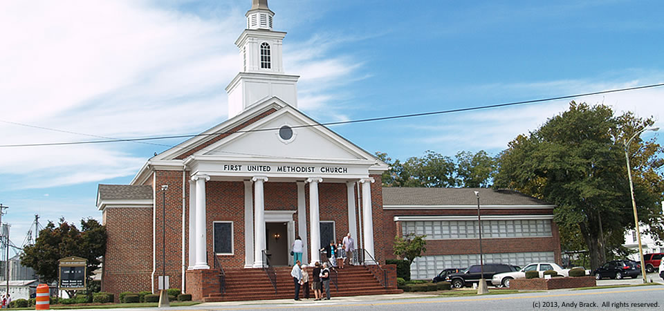
Members of the First United Methodist Church in Sylvania in eastern Georgia are shown leaving church on a fall Sunday.  Despite the fact that Southern states tend to be more conservative than states in other parts of the country, Southerners tend to be more generous with larger percentages of their discretionary income going to charity.

According to the Chronicle of Philanthropy, four Southern states — Mississippi, Alabama, Tennessee and South Carolina — are in the top five most charitable states.  Georgia ranks eighth, according to a 2012 study.

Sylvania, the county seat of Screven County, had 2,675 people in 2000, according to the Census.  Screven County got its start after the Revolutionary War and soon became part of the Black Belt of Georgia where cotton became an important staple crop tended by enslaved African Americans.

The county’s population jumped from 3,019 in 1800 to 8,274 by 1860, according to Census figures.  While it had 14,593 people in 2010, the county lost an estimated 391 people — 2.7 percent — by 2012, according to the U.S. Census.  In 2010, Some 25.4 percent of county residents lived below the federal poverty level, 9 points higher than the state average.

Photo taken Sept. 22, 2013, by Andy Brack.  All rights reserved.


Trash bins, Emanuel County, Ga.

13.1011.trash_ga

Overflowing trash bins like this pair at the southeastern tip of Emanuel County near where it joing Bullock and Candler counties seem more common in rural areas of the Southern Crescent where garbage pick-up is limited.

This photo was taken just north of the intersection of U.S. Highway 80 and Georgia Highway 121 in Emanuel County, which has almost 23,000 people and a poverty rate of 24.5 percent, according to the U.S. Census.

Photo taken Sept. 22, 2013, by Andy Brack.  All rights reserved.

Old barn, Emanuel County, Ga.

13.1008.barn

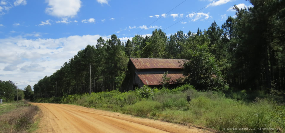
Orange dirt roads.  Pine trees.  Cotton fields.  This photo evokes the writing of Georgia’s Erskine Caldwell.  It was taken in Georgia’s cotton country just north of the intersection of U.S. Highway 80 and Georgia Highway 121 in Emanuel County.

According to the Cotton Council International 2013 Buyers’ Guide, Georgia farmers grew more than 15 percent of the nation’s cotton in 2011-12 by producing 2.465 million bales.  The only state that grew more cotton was Texas, which produced 3.5 million of the nation’s 15.573 million bales in 2011-12.

Emanuel County,located north of Statesboro, Ga., has almost 23,000 people and a poverty rate of 24.5 percent, according to the U.S. Census.

Photo taken Sept. 23, 2013, by Michael Kaynard.  All rights reserved.