Old gin, Salters, S.C.

Old cotton gin, Salters, S.C.

Old cotton gin, Salters, S.C.

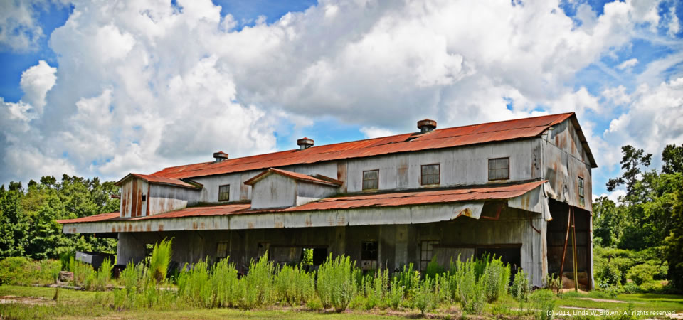
Here’s another old South Carolina cotton gin, this one in the rural community of Salters in Williamsburg County.

Retired editor Linda W. Brown, who took the photo, notes that the Salters gin not only provided employment for the adults of the community, but it also was a source of recreation for the young people.  One woman who grew up there remembers “jumping cotton bales which were stacked at the gin ‘for recreation.’ She believes the gin closed somewhere around 1970. She says that during the time of year the gin was in operation, the three stores in ‘town’ stayed open late into the night.”

Residents, who often refer to themselves as “Saltines,” love their community and many fight hard to keep out landfills or growth of a current one, Brown writes.

“Visiting Salters for me is like stepping back in time to an era when people spent the afternoons sitting on their front porches watching the trains go by,” Brown writes.

Williamsburg County, located in the middle of the Southern Crescent, is about 75 miles north of Charleston, S.C.  Just under 34,000 people live in the county, which is about the number who lived there in 1900, according to Census figures.  Population peaked in 1950 at 43,807, but has dropped slowly since then.

About two-thirds of county residents are black, with almost  all of those remaining being white.  Only 2 percent of those in the county are of Hispanic descent.  Some 32.8 percent of residents live in poverty, according to the Census.  Of the county’s 1,921 firms, 36.5 percent are black-owned — a percentage that is three times South Carolina’s average.

Copyrighted photo by Linda W. Brown, courtesy of the photographer.  All rights reserved.
Old gin, Salters, S.C.

Old cotton gin, Salters, S.C.

The cotton gin in Salters not only provided employment for adults in the rural Williamsburg County community, but it was a source of recreation for young people, former editor Linda W. Brown writes.

“Beth Moseley Tisdale grew up in Salters, and she remembers jumping cotton bales which were stacked at the gin ‘for recreation.’ She believes the gin closed somewhere around 1970. She says that during the time of year the gin was in operation, the three stores in ‘town’ stayed open late into the night.”

Residents, who often refer to themselves as “Saltines,” love their community and many fight hard to keep out landfills or growth of a current one, Brown says.

“Visiting Salters for me is like stepping back in time to an era when people spent the afternoons sitting on their front porches watching the trains go by,” she writes.

Williamsburg County, located in the middle of the Southern Crescent, is about 75 miles north of Charleston, S.C.  Just under 34,000 people live in the county, which is about the number who lived there in 1900, according to Census figures.  Population peaked in 1950 at 43,807, but has dropped slowly since then.

About two-thirds of county residents are black, with almost  all of those remaining being white.  Only 2 percent of those in the county are of Hispanic descent.  Some 32.8 percent of residents live in poverty, according to the Census.  Of the county’s 1,921 firms, 36.5 percent are black-owned — a percentage that is three times South Carolina’s average.

Copyrighted photo by Linda W. Brown, courtesy of the photographer.  All rights reserved.

Old depot, Salters, S.C.

Old depot, Salters, S.C.

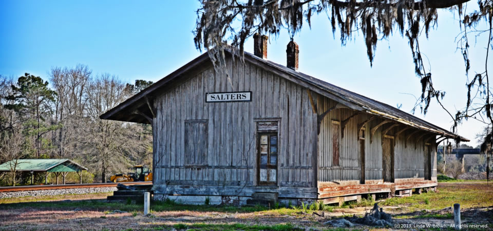
This old railroad depot in the unincorporated community of Salters, S.C., looks almost exactly like a depot we featured in June that’s in Leary, Ga.

Former editor Linda W. Brown tells us that the old depot was built in the 1850s when the railroad came to town and served the community for about 100 years.  “The community was actually known as Salters Depot for many years,” she writes.  “Charlie Walker never called it anything else although he pronounced the last syllable as if it were a cooking utensil. Salters has always been an agricultural community and the depot primarily handled ag products.”

Residents, who often refer to themselves as “Saltines,” love their community and many fight hard to keep out landfills or growth of a current one, Brown writes.

“Visiting Salters for me is like stepping back in time to an era when people spent the afternoons sitting on their front porches watching the trains go by,” she writes.

Williamsburg County, located in the middle of the Southern Crescent, is about 75 miles north of Charleston, S.C.  Just under 34,000 people live in the county, which is about the number who lived there in 1900, according to Census figures.  Population peaked in 1950 at 43,807, but has dropped slowly since then.

About two-thirds of county residents are black, with almost  all of those remaining being white.  Only 2 percent of those in the county are of Hispanic descent.  Some 32.8 percent of residents live in poverty, according to the Census.  Of the county’s 1,921 firms, 36.5 percent are black-owned — a percentage that is three times South Carolina’s average.

Copyrighted photo by Linda W. Brown, courtesy of the photographer.  All rights reserved.
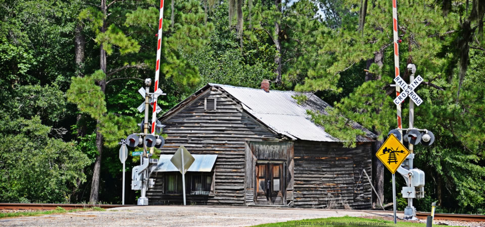
Old store, Salters, S.C.

Moseley store, Salters, S.C. Photo by Linda W. Brown.

Salters is an unincorporated small community in southwestern Williamsburg County, South Carolina.  Former editor Linda W. Brown writes that the residents, who like to call themselves “Saltines,” love their community and many fight hard to keep out landfills or growth of a current one.

“Visiting Salters for me is like stepping back in time to an era when people spent the afternoons sitting on their front porches watching the trains go by,” she writes.

Years back, you could easily watch trains go by from the front of this store pictured above.  It’s the old C.E. Moseley Store and remains in the Moseley family.  “I’m not sure when it was built, but it was open until 1943 when the Moseleys moved across the railroad tracks to a larger building,” which operated until the late 1980s.

Williamsburg County, located in the middle of the Southern Crescent, is about 75 miles north of Charleston, S.C.  Just under 34,000 people live in the county, which is about the number who lived there in 1900, according to Census figures.  Population peaked in 1950 at 43,807, but has dropped slowly since then.

About two-thirds of county residents are black, with almost  all of those remaining being white.  Only 2 percent of those in the county are of Hispanic descent.  Some 32.8 percent of residents live in poverty, according to the Census.  Of the county’s 1,921 firms, 36.5 percent are black-owned — a percentage that is three times South Carolina’s average.

Copyrighted photo by Linda W. Brown, courtesy of the photographer.  All rights reserved.
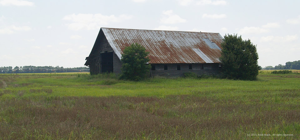
Barn, near Rowland, N.C.

Barn along Interstate 95 near Rowland, N.C.  Photo by Andy Brack.
Barn along Interstate 95 near Rowland, N.C. Photo by Andy Brack.

This quaint old barn sits in a field next to the mobile home and farmhouse profiled in our Aug. 12 post.  It’s located near Rowland, N.C., about a mile north of the famous South of the Border attraction at the South Carolina-North Carolina line along Interstate 95.

Rowland had 1,146 people in 2000, including more than 30 percent in poverty.  It’s also part of Robeson County, which is considered a majority-minority county (as are about 10 percent in the country) because its populations of native Americans, blacks and Hispancs total more than 50 percent.

In 2012, Robeson County had an estimated 135,496 people comprised of 39 percent American Indians, 32.8 percent whites, 24.7 percent blacks and 8.2 percent Hispanic, according to the Census.  Some 30.6 percent of county residents lived at or below the federal poverty level.

Photo taken July 26, 2013, by Andy Brack, Center for a Better South.  All rights reserved.

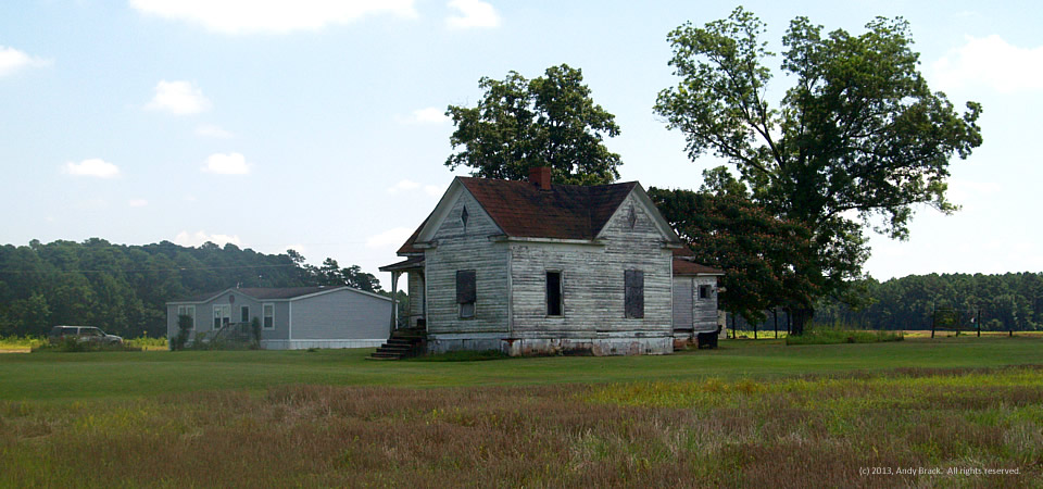
Two homes, near Rowland, N.C.

Mobile home next to old farmhouse, near Rowland, N.C.

So this is how it is in parts of the rural South — a family’s mobile home is where they live while the old farmhouse they grew up in is next door.  These homesteads are just off Interstate 95 outside of Rowland, N.C., near the South Carolina border and its infamous South of the Border attraction.

Rowland had 1,146 people in 2000, including more than 30 percent in poverty.  It’s also part of Robeson County, which is considered a majority-minority county (as are about 10 percent in the country) because its populations of native Americans, blacks and Hispancs total more than 50 percent.

In 2012, Robeson County had an estimated 135,496 people comprised of 39 percent American Indians, 32.8 percent whites, 24.7 percent blacks and 8.2 percent Hispanic, according to the Census.  Some 30.6 percent of county residents lived at or below the federal poverty level.

Photo taken July 26, 2013, by Andy Brack, Center for a Better South.  All rights reserved.

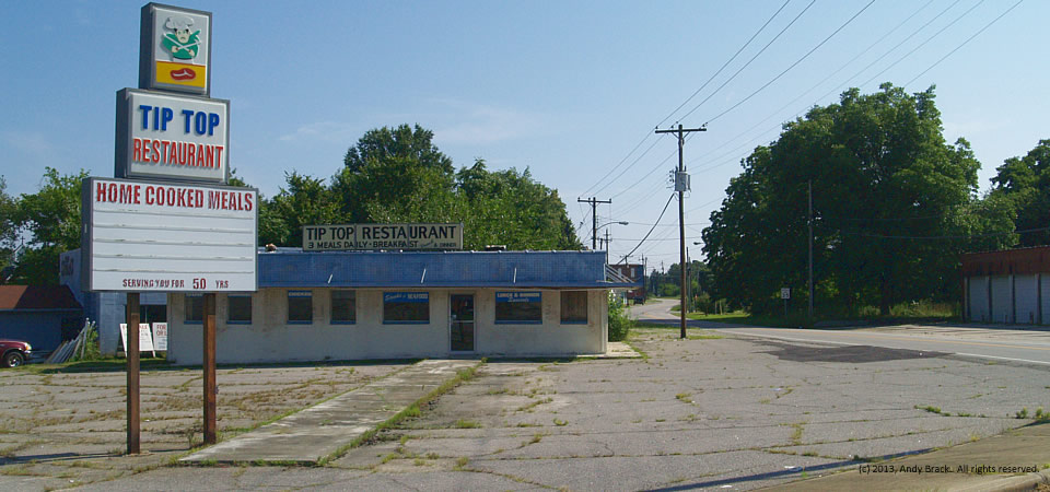
Closed restaurant, Henderson, N.C.

Old Tip Top Restaurant, Henderson, N.C.  Photo by Andy Brack.
Old Tip Top Restaurant, Henderson, N.C. Photo by Andy Brack.

We bet the meat-and-three lunch specials at the Tip Top Restaurant on Garnett Street in Henderson, N.C., were outstanding in their day.  More than likely, the workers from the cotton mill just down the street flooded into the place in days gone by.  [See our entry on the mill.]

But the Tip Top doesn’t offer three home-cooked meals anymore, a sure victim of globalization and today’s economic times in the Southern Crescent.  A review from 2003 recalls the restaurant as having a relaxed atmosphere that offered good food, “just like being at home.”   Said the reviewer:  “‘Eating Out Can Be Fun” has been their slogan for 48 years!'”

Henderson, part of Vance County, had 15,320 people in 2010, according to Census estimates. Almost two thirds of residents are black. A third of residents live at or below the federal poverty level.  In April 2013, the county’s unemployment rate was 11.7 percent.

Photo taken July 24, 2013 by Andy Brack, © 2013. All rights reserved.

Gutted textile mill, Henderson, N.C.

Gutting of Henderson Cotton Mill, Henderson, N.C.  Photo by Andy Brack.
Gutting of Henderson Cotton Mill, Henderson, N.C. Photo by Andy Brack.

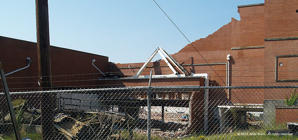
You can see how the interior of the old Henderson Cotton Mill is gutted into a pile of bricks in the center of this photo.

The photo represents the flip side of a story of huge success at the beginning of the last century.  Now as the mill is being razed and salvage workers are removing valuable old wood and bricks, the mill is a testament to how America’s textile industry went overseas.  Once the driver of Henderson’s economy, the yarn mill and nearby sister mill represent the gutting of the rural South’s economic engine.

“The reason they’re tearing down is they can’t afford the taxes on it,” a 37-year plant veteran told the local newspaper. “The buildings are in good shape, but it was the taxes. Nobody who worked there likes to see this. We all hate to see it go, but what can you do?”

The Henderson Cotton Mill, organized in 1895, got started the following year on the north side of Henderson. Its success led to the opening of another mill, the Harriet Cotton Mill, on the south side of the town in 1901. Both mills were major producers of cotton yarn, according to NCPedia.

The mills joined organized labor in 1943. By the end of the 1950s with modernization and global competition, workers agreed to strike, which closed the mills until February 1959 when the owners reopened with non-union workers. A contract was negotiated by that April, but by the time the strike ended in 1961, more than 60 union members or sympathizers were tried and convicted of various acts of violence, the site said.

The Henderson and Harriet mills apparently consolidated in 1995 as Harriet & Henderson Yarns, but filed for bankruptcy in 2003 and closed its doors, according to the University of North Carolina University Libraries.

Henderson, part of Vance County, had 15,320 people in 2010, according to Census estimates. Almost two thirds of residents are black. A third of residents live at or below the federal poverty level.

Photo taken July 24, 2013 by Andy Brack, © 2013. All rights reserved.

Razing of textile mill, Henderson, N.C.

Henderson Cotton Mill, Henderson, N.C.  Photo by Andy Brack.
Henderson Cotton Mill, Henderson, N.C. Photo by Andy Brack.

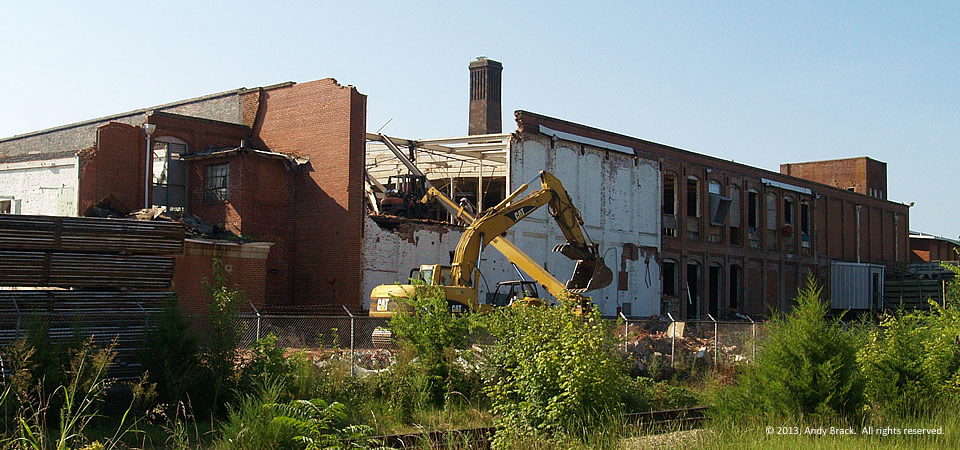
The old Henderson Cotton Mill, a story of huge success at the beginning of the last century, is now coming down in this century, the victim of a textile industry that went overseas.

The building in the northern part of the northeastern North Carolina town of Henderson is being razed as salvage workers remove valuable old wood and bricks. Once the driver of Henderson’s economy, the yarn mill and nearby sister mill are testaments to the gutting of the rural South’s economic engine.

“The reason they’re tearing down is they can’t afford the taxes on it,” a 37-year plant veteran told the local newspaper. “The buildings are in good shape, but it was the taxes. Nobody who worked there likes to see this. We all hate to see it go, but what can you do?”

The Henderson Cotton Mill, organized in 1895, got started the following year on the north side of Henderson. Its success led to the opening of another mill, the Harriet Cotton Mill, on the south side of the town in 1901. Both mills were major producers of cotton yarn, according to NCPedia.

The mills joined organized labor in 1943. By the end of the 1950s with modernization and global competition, workers agreed to strike, which closed the mills until February 1959 when the owners reopened with non-union workers. A contract was negotiated by that April, but by the time the strike ended in 1961, more than 60 union members or sympathizers were tried and convicted of various acts of violence, the site said.

The Henderson and Harriet mills apparently consolidated in 1995 as Harriet & Henderson Yarns, but filed for bankruptcy in 2003 and closed its doors, according to the University of North Carolina University Libraries.

Henderson, part of Vance County, had 15,320 people in 2010, according to Census estimates. Almost two thirds of residents are black. A third of residents live at or below the federal poverty level.

Photo taken July 24, 2013 by Andy Brack, © 2013. All rights reserved.

Old Masonic Hall, Waverly, Va.

Old Masonic Hall, Waverly, Va.  Photo by Andy Brack.
Old Masonic Hall, Waverly, Va. Photo by Andy Brack.

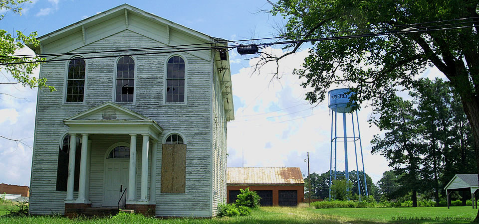
At first, we thought this was an old church, especially since it is across a field from what we took for a newer incarnation of the Waverly International Congregational Church on Coppahaunk Avenue.

But it turns out this building with plywood over some of the windows is actually the small community’s old Masonic Hall, according to an old friend who is distressed about the slow decay of his hometown these days.  “It was a great place to grow up,” he remembers.

Waverly, which had 2,149 residents in 2010 (160 fewer than 10 years earlier), is in rural Sussex County, a heartland of Virginia’s famous peanuts.  Sussex County, which had more than 20 percent of people living in poverty in 2000, has some 15.6 percent of people in poverty as of the 2010 Census.  About 60 percent of the county’s residents are black.

Copyrighted photo taken July 23, 2013, by Andy Brack, Center for a Better South. All rights reserved.